

A recently launched satellite designed to study all water across the world has begun sending its first images back to Earth.
The American space agency NASA says the satellite is expected to measure the elevation of nearly all water on Earth’s surface. It is the largest and most detailed effort yet to map the world’s water.
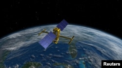
The satellite is called SWOT, which stands for Surface Water and Ocean Topography. SWOT is a joint project between NASA and the French space agency, CNES.
The satellite uses radar technology and other instruments to collect detailed height and surface measurements of water in oceans, lakes and rivers. Oceans cover more than 70 percent of Earth’s surface.
Researchers say the information can help them learn more about how the world’s water supply influences climate change.
One major goal of the project is to research how oceans take in atmospheric heat and carbon dioxide. The natural process moderates temperatures and climate change.
Data will be recorded from radar readings on about 90 percent of Earth’s surface. Such data can support efforts to learn about ocean currents, predict the weather and control freshwater supplies in areas with little rain, NASA says.
The information is also expected to assist communities as they seek to improve and manage their water resources and prepare for floods and other disasters, the researchers said.
NASA Administrator Bill Nelson spoke about SWOT’s activities as the first observations of the world’s water supply arrived to Earth.
“SWOT’s advanced imagery will empower researchers and advance the way we manage fresh water and the effects of sea level rise” across the world, Nelson said in a statement. He added that water is one of the planet’s most important resources and is threatened by elements of climate change.
“SWOT will provide critical information that communities can use to prepare for the impacts of a warming climate,” Nelson added.
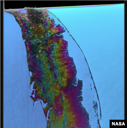
The images use colors to identify elevation levels in different bodies of water. In one example of its first work, SWOT measured sea levels off the coast of North Carolina and Virginia. A radar instrument on the satellite collected data on an ocean area about 120 kilometers across.
NASA said red and orange areas in the images represented sea levels that were higher than the worldwide average. On the other hand, areas shown in blue represented sea levels that were lower than average.
The research team involved in the project said SWOT provides big improvements over measurements captured by other space-based instruments called altimeters. Those instruments are only able to look at a narrow area of Earth directly beneath them. But NASA says SWOT’s instruments are designed to observe sea levels across much wider areas.
SWOT's radar instrument can also collect data through clouds and darkness. This will permit scientists to map observations under different weather conditions and cover large areas at any time of day.
Philippe Baptiste is the chairman and chief executive of CNES. He said in a statement, “Our ability to measure freshwater resources on a global scale through satellite data is of prime importance as we seek to adjust to a changing climate.”
He added: “The first views from SWOT give us a clearer picture than ever before. These data will prove highly valuable for the international community in the fields of hydrology, oceanography, and coastal studies.”
Parag Vaze is a SWOT project manager at NASA’s Jet Propulsion Laboratory in California. He said he hopes researchers, policymakers and water resource managers around the world will examine the data collected by SWOT.
“(The satellite) took years to develop and build,” Vaze said, “and it will collect information on bodies of water across the globe – data that will be freely and openly available to everybody who needs it.”
I’m Bryan Lynn.
Bryan Lynn wrote this story for VOA Learning English, based on reports from NASA and France’s National Center for Scientific Research.
Quiz - NASA’s Water-observing Satellite Sends First Images back to Earth

Start the Quiz to find out
_________________________________________________________________
Words in This Story
elevation – n. the height of a place above sea level
manage – v. to do something or deal with something successfully
advanced – adj. having developed or progressed to a late stage
impact – n. the effect a person, event or situation has on someone or something
prime – adj. main or most important
adjust – v. to change something slightly to get it to work better
hydrology – n. the study of Earth’s water supply
__________________________________________________________________
What do you think of this story? We want to hear from you. We have a new comment system. Here is how it works:
- Write your comment in the box.
- Under the box, you can see four images for social media accounts. They are for Disqus, Facebook, Twitter and Google.
- Click on one image and a box appears. Enter the login for your social media account. Or you may create one on the Disqus system. It is the blue circle with “D” on it. It is free.
Each time you return to comment on the Learning English site, you can use your account and see your comments and replies to them. Our comment policy is here.
Forum